

In today's era where everything is being tracked, monitored, and analyzed by high-altitude eye-in-the-sky assets, we are overwhelmingly dependent on technology to alert us to existential crises. Somehow, this unprecedented flood of data is remarkably useful for diagnosing our planetary errors, and somehow, it is completely ignored. We have engineered instruments capable of measuring sub-millimeter tectonic shifts from hundreds of kilometers above the exosphere, yet we remain entirely paralyzed when it comes to translating that continuous digital diagnostic into tangible, defensive public policy. Spaceborne reconnaissance was originally conceptualized to make military intelligence faster, target identification sharper, and national security execution operate with better efficiency. But when we just ended up depending entirely on automated dashboards, colorful geospatial visualizations, and passive threat monitoring systems for our long-term safety, we don't know where we actually lost the old, aggressive methods of real-world administrative management, decisive engineering interventions, and strict municipal discipline. We don't know why data collection became an end in itself rather than a catalyst for architectural structural survival.
So this article basically is going to get you all aware about what we should do with spaceborne intelligence and what we must urgently execute with authentic, aggressive urban engineering to stop the quiet, downward collapse of our most vital macroeconomic centers.
Radar Interferometry and the Shocking Precision of Sinking Cities
With advanced remote sensing technologies, tracking structural degradation has become easier and incredibly efficient to calculate the physical deformities of our daily civic infrastructure, urban environments, macroeconomics, and commercial centers. Space agencies and defensive reconnaissance loops are no longer just looking at visual photographs; they are deploying synthetic aperture radar (SAR) constellations that act as ultraprecise "spy tools" for structural geology. These "agentic" monitoring systems can bounce microwave signals off concrete pillars, highway systems, residential skyscrapers, and airport runways to analyze minute structural shifts, forecast ground structural failure, detect invisible foundational stress, and even diagnose underground water table collapses with minimal manual on-ground deployment. These spaceborne assets provide unparalleled risk management metrics by tracking surface deformation using a method known as Interferometric Synthetic Aperture Radar (InSAR). By comparing the phase shift between multiple radar pulses sent from orbit over weeks and months, the system computes vertical ground displacement with absolute millimeter accuracy. The formula governing this phase-to-displacement conversion is expressed through the geometric relationship of the radar wavelength:
Δφ = −(4π / λ) × Δr
Where Δφ represents the observed interference phase shift, λ is the operational microwave sensor wavelength (typically around 5.6 cm for C-band radar or 24 cm for L-band radar), and Δr dictates the real-world change in distance along the satellite's line of sight. Through this relentless orbital math, India's specialized spy and scientific radar configurations have unlocked a deeply terrifying reality: our primary financial engines are systematically down-warping into the earth.
"We build skyward with blind hubris while the ground beneath our foundations quietly dissolves into the sea."
The sheer velocity of the subsidence is staggering. Let's look at the actual metrics recorded across major urban landscapes. Delhi's National Capital Region (NCR), particularly areas around Kapashera and Faridabad, is experiencing localized sinking rates exceeding 50 to 80 millimeters per fiscal year. Kolkata, built upon a fragile, highly compressible deltaic clay layer, is subsiding at an average rate of 20 mm annually, with specific commercial zones dropping even faster. Meanwhile, the financial powerhouse of Mumbai is showing structural warping up to 30 mm per year in reclaimed coastal strips. This isn't just geological evolution; it is an active structural emergency that is threatening hundreds of billions of dollars in fixed real estate assets.
Cons of Using Purely Passive Monitoring Loops
Data as we know is still just passive information, not a human-based policy mindset which can think dynamically like a crisis commander and execute hard engineering decisions after calculating endless economic possibilities in every local scenario. In recent governance studies, it was observed that major state authorities do receive extensive, high-fidelity satellite datasets, but with heavier, longer, and more confusing bureaucratic reporting structures where every critical warning is buried under a vast cloud of academic jargon. A staggering difference of 65% inefficiency was seen in municipal response times, which calculates to mean that nearly every 2nd out of 5th critical subsidence alert generated by orbital observation platforms completely stalls within administrative committee loops. This leaves a massive gap in infrastructure preservation which, if left unaddressed in small rural zones might only damage local farms, but in mega-commercial zones can plunge the entire banking, real estate, and corporate framework into a sudden, unrecoverable disaster. Giving endless technical briefs and keeping records neatly stacked on server drives without active engineering intervention becomes a tiring, endless loop of observing records get worse and doing absolutely nothing about it, which becomes an exhausting political chore that takes up massive research budgets but provides major structural headaches and multi-billion-dollar losses in the immediate future.
The Data-Action Inversion Trap
The fundamental flaw of modern tech-dependent infrastructure management is the belief that observation equals mitigation. Satellites can measure the exact velocity of a bridge fracturing or an urban block sinking, but an orbit-to-ground pipeline does not exist to automatically trigger concrete injection, aquifer recharge, or zoning bans.
The Root Causes: Why Cities are Warping Under Their Own Weight
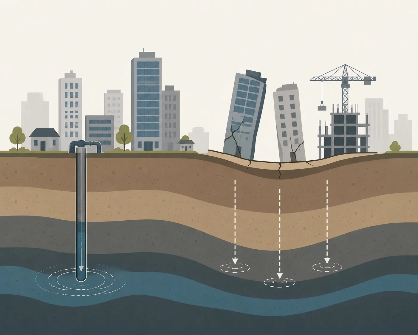
To understand why our modern spaces are structurally failing, we must look at the hidden mechanics of urban development. The primary driver of real-time sinking across almost all major metropolitan sectors isn't a mysterious shift in the Earth's core; it is the chaotic, uncontrolled extraction of deep groundwater resources combined with reckless building loads on fragile geologies.
Advertisement
When thousands of illegal borewells, industrial deep-pumps, and commercial residential hubs extract millions of liters of water daily from subsurface aquifers, they empty the pore spaces within the deep soil matrix. Without the hydrostatic pressure of water to support the overlapping sediment, the weight of the city collapses the empty spaces. This phenomenon, known as aquifer compaction, causes the ground surface above to drop irreversibly. The relationship between the change in effective stress (σ'), total overburden pressure (σ), and pore water pressure (u) is defined by the foundational geotechnical principle:
σ' = σ − u
As groundwater extraction rapidly minimizes the pore water pressure (u), the effective stress (σ') borne by the soil particles increases exponentially. The soil grains pack tightly together, the entire subsurface layer contracts, and the heavy concrete structures built on top begin to tilt, crack, and drop into the shifting earth. This structural damage is completely irreversible; once an aquifer is compacted to its absolute limit, it can never hold water again, permanently altering the hydrology of the region.
Structural Comparison: Passive Space Alerts vs. Hard Practical Mitigation
| Urban Region | Satellite Measured Subsidence Rate | Primary Subsurface Vulnerability | Administrative Action Status |
|---|---|---|---|
| Delhi NCR (Kapashera/Faridabad) | 50 – 82 mm/year | Extreme aquifer depletion via unregulated borewells; rapid load over loose alluvium. | BROKEN — Monitoring active, enforcement zero. |
| Mumbai (Coastal Reclaimed Zones) | 20 – 30 mm/year | Intertidal mudflat consolidation; heavy coastal structural load; rising sea level alignment. | PENDING REVIEW — Data filed, infrastructure planning unadjusted. |
| Kolkata (Eastern Sectors) | 15 – 25 mm/year | Deep organic clay compaction; massive drainage failure; accelerating water logging. | BROKEN — Ignored in local municipal building permits. |
| Bengaluru (Tech Corridors) | 10 – 15 mm/year | Drying of historical lake beds; fractured hard rock aquifer collapse under severe tech park loads. | STALLED — Under academic committee assessment. |
The Bureaucratic Inertia: Why Nobody is Acting on the Satellite Signals
Why is there an absolute disconnect between the brilliant, crisp satellite radar streams and the actual concrete mixers on the ground? The answer lies inside the fragmented, compartmentalized, and defensive nature of modern public administration. The space assets and tracking telemetry are managed by elite national scientific and defense bodies, while the actual power to enforce building laws, stop illegal extraction, and mandate massive civil engineering overhauls belongs to local municipal corporations, corrupt regional water boards, and real estate departments. These two separate entities almost never communicate effectively. A defense satellite detects that a massive commercial zone housing fifty IT hubs is dropping by 4 centimeters a year, indicating imminent utility pipeline shearing and foundational fracturing. This alarming data is compiled into an expensive, highly classified report. It travels through multi-layered central committees, takes six months to clear security clearance, and finally lands on the desk of a local city commissioner who has neither the budget, the structural engineering training, nor the political will to shut down a highly profitable commercial zone or confront powerful building syndicates.
The result is a culture of total stagnation. The national agencies keep launching sharper, more sophisticated satellites, gathering cleaner data, and printing prettier graphs, while the cities continue their downward journey into the mud, completely unbothered by the orbital eye watching their slow-motion collapse.
"An orbital alarm system is completely useless if the fire department on the ground refuses to look at the screen."
The Final Verdict: Shifting from High-Tech Observation to Real-World Survival
We must understand that high-tech monitoring tools cannot mix concrete, they cannot legally block real estate corruption, they cannot actively recharge an aquifer, and they absolutely cannot hold up a collapsing city block through sheer computational brilliance. The magic of true risk management dictates that when you manually map, aggressively regulate, and directly construct engineering defenses ourselves, the public administration becomes hyper-aware of what it is building and whether it is safe or completely dangerous to develop in specific ecological zones. This eventually becomes an ironclad habit to check geological safety twice before spending or investing millions of dollars in public funds, which is the core principle of long-term success in infrastructure survival, financial management, and national preservation. If we do not bridge this massive divide between state-of-the-art satellite intelligence and ground-level municipal execution immediately, we will face catastrophic structural failures. Skyscraper foundations will shear, major rapid transit networks will warp out of alignment, and coastal metropolis zones will find themselves suddenly swallowed by sea-level rises far ahead of climate projections, all because we chose to passively observe the data rather than aggressively act upon it.
Read Further
- Building Damage Risk in Sinking Indian Megacities — Nature Sustainability, 2025: Satellite radar analysis of 13 million buildings across Delhi, Mumbai, Chennai, Kolkata and Bengaluru
- Ground Subsidence Monitoring in India Using InSAR: A Review of Current Status and Future Prospects — India Water Portal
Disclaimer: All the data and facts provided above were compiled from various internet resources, scientific remote sensing journals, and international radar interferometry studies done upon global urban subsidence trends. This comprehensive structural analysis should not be taken as an official quote from our website or definitive structural engineering advice for specific real estate developments.
Advertisement