

In today's era where everything is being digitized, monitored by satellites, and mapped by state-of-the-art computational algorithms, we are too much dependent on technology on paper, and somehow it is useful for us and somehow it is not. We live in a false sense of security, believing that because a warning system has been designed, budgeted, and launched in a glamorous press release, the vulnerable populations living downstream in our majestic Himalayan valleys are safe. But the reality on the ground is starkly different, terrifyingly silent, and dangerously unequipped. Technology and automated monitoring systems are something that were created to make our disaster management responses faster and with better efficiency. But when we just ended up depending on heavy paperwork, standard operating procedures, and autonomous early warning proposals for our everything, we don't know where we actually forgot the practical ground realities, the old indigenous wisdom of mountain observation, and true operational discipline. We don't know why the transition from a digital dashboard to a physical siren on a river bank takes years, while a glacial lake can burst open in a matter of seconds.
So this article basically is going to get you all aware about what we should do with modern telemetry and automated Early Warning Systems (EWS) and what we should do with the authentic, original, and urgent ground-level structural deployment required to secure our mountain communities and manage climate risk. We will deep-dive into the massive numbers, the hard data, the scientific gaps, and why a country with unparalleled technological prowess is still struggling to put physical sensors on its most dangerous high-altitude water bodies.
The Frozen Giants: 7,500 Glacial Lakes and the Looming Threat
The Third Pole — the massive Hindu Kush-Himalayan region — holds the largest volume of ice outside the polar regions. Within India's boundaries alone, across states like Sikkim, Uttarakhand, Himachal Pradesh, Jammu & Kashmir, and Arunachal Pradesh, recent satellite inventories show an astonishing presence of over 7,500 glacial lakes. These lakes form when glaciers melt and retreat due to global warming, leaving behind vast bodies of water trapped only by unstable, loose walls of rocks, boulders, and ice debris called moraines. With global temperature anomalies breaking records every year, these glaciers are retreating at an unprecedented pace of 15 to 30 meters annually. As they shrink, the volume of water accumulating in these moraine-dammed lakes increases exponentially. The primary danger here is Glacial Lake Outburst Floods (GLOFs). A GLOF occurs when the fragile debris dam holding back the lake fails completely, triggered by an avalanche, a cloudburst, an earthquake, or simply internal hydrostatic pressure. When that happens, millions of cubic meters of water, mud, and heavy boulders tear down the steep mountain valleys, destroying everything in their path.
"Climate risk is shifting from a future prediction to a present catastrophe. In the high Himalayas, billions of tons of water are suspended above thousands of sleeping villages, waiting for a single fracture to transform peace into absolute devastation."
Recent scientific surveys have categorized at least 200 of these 7,500 glacial lakes as 'High-Risk' or critically vulnerable to immediate outburst. These high-risk zones are concentrated heavily in the Eastern and Central Himalayas. Despite this immense and well-documented hazard, the execution of active defense systems remains shockingly stagnant. We have excellent satellite maps generated by organizations like ISRO and the National Remote Sensing Centre (NRSC), but a satellite map cannot sound a local alarm in a village when a mountain splits open at 2:00 AM.
Automated Telemetry Systems and the Illusion of Efficiency
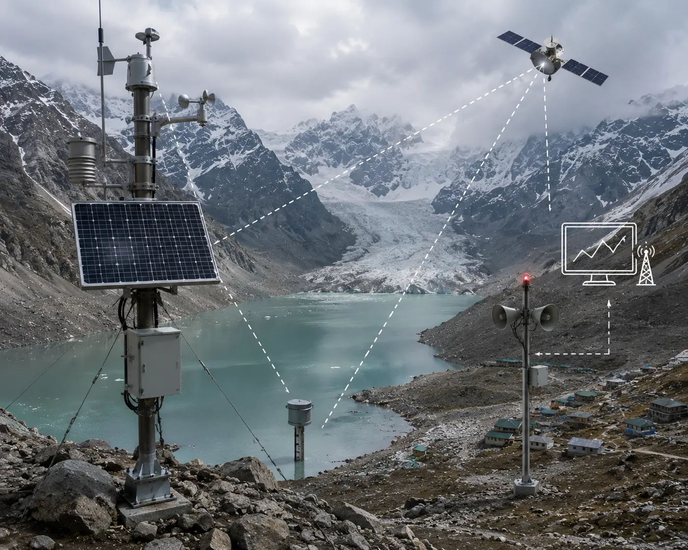
When we look at modern disaster management portfolios, automated technology appears incredibly advanced. The planned Early Warning Systems for GLOFs are designed as highly sophisticated, "agentic" networks. In theory, an ideal automated early warning system consists of multiple components working in perfect synergy:
- Water Level Sensors: High-altitude radar or ultrasonic water level gauges installed directly at the lake site to monitor sudden, unusual fluctuations in water depth.
- Automated Weather Stations (AWS): Telemetry systems that track immediate temperature spikes, extreme rainfall, or wind barometrics that could accelerate glacial melting.
- Satellite Transmitters: Solar-powered data loggers that transmit real-time data from 4,500 meters above sea level to central emergency operations rooms via dedicated communication satellites.
- Downstream Acoustic Sirens: Automated electronic sirens positioned in vulnerable valley settlements, programmed to trigger automatically if the upstream water levels cross a lethal threshold.
On paper, this system offers incredible efficiency. It promises to give downstream populations anywhere between 30 minutes to 2 hours of advance warning time to evacuate to higher ground. In a business context, such automation saves assets; in a human context, it saves thousands of lives. Major technology vendors and state authorities frequently showcase these architectures as the ultimate shield against climate wrath. Yet, despite these brilliant architectural blueprints, the physical reality of these systems across the 7,500 lakes is practically invisible.
Cons of Depending Solely on Paper Blueprints and Digital Progress
The massive gap between a paper plan and a functioning mountain sensor comes with heavy costs. Technology, as we know, is still artificial and machine-dependent; it lacks a human-based mindset that can navigate the treacherous physical terrains and complex bureaucratic landscapes of the Indian subcontinent. In recent operational evaluations, a vast and troubling difference has been observed between what is reported in capital cities and what actually works in the freezing altitudes. A major study of implemented high-altitude telemetry systems reveals an active failure rate of nearly 65% under extreme environmental conditions. This means that 2 out of every 5 sensor installations fail, stop transmitting, or provide faulty calibration data within their first winter season. The harsh Himalayan climate — where temperatures plunge below minus 30 degrees Celsius, solar panels are covered by thick blankets of snow for months, and fierce blizzards misalign satellite antennas — leaves an unforgiving margin of error in budgeting and safety planning. If an error happens in a household budget, you lose money, but if an error happens in a GLOF early warning sensor, whole valleys vanish from the map.
Furthermore, relying purely on heavy tech procurement processes creates an endless loop of administrative delay. Government departments get caught in continuous cycles of issuing tenders, evaluating technical bids, facing vendor disputes, and rewriting technical requirements because the previous criteria were deemed outdated. Giving bureaucratic prompts and continuously checking paperwork becomes a tiresome chore of the day, taking years of valuable time and administrative headspace, while delivering major structural headaches and zero physical safety to the communities on the ground.
"We cannot combat an accelerating physical crisis with digital promises. A warning system that exists only as a budget line item or an unfulfilled policy draft provides zero decibels of sound when the torrent arrives."
Lessons from Past Tragedies: When the Paper Failed
The devastating consequences of keeping early warning systems on paper are not hypothetical; they are written in the tragic history of the past decade. The Indian Himalayan region has experienced repeated warnings, yet the pace of implementation remains painfully slow. Let us look at the hard facts of recent catastrophes:
1. The South Lhonak Lake Disaster (Sikkim, 2023)
In October 2023, a massive cloudburst triggered a GLOF at the South Lhonak Lake in North Sikkim. More than 100 lives were lost, and critical infrastructure, including the massive Teesta III dam, was completely washed away. Scientific authorities had known for over a decade that this lake was a ticking time bomb. Attempts to install an early warning system had been delayed repeatedly due to logistics and procurement hurdles. When the lake burst, there was no automated siren system to warn the downstream citizens or the military installations, resulting in complete devastation.
Advertisement
2. The Chamoli Rock Ice Avalanche (Uttarakhand, 2021)
A huge mass of rock and ice broke off a glacier, causing a massive flash flood in the Rishi Ganga and Dhauliganga rivers. Over 200 people, mostly laborers working inside hydro-power tunnels, were trapped and killed. There was absolutely no real-time telemetry or upstream automated sensor network to send an alert down the valley, even though plans for comprehensive mountain monitoring had been discussed in high-level committees for years.
3. The Kedarnath Deluge (Uttarakhand, 2013)
The bursting of the Chorabari glacial lake combined with heavy rain led to the deaths of thousands of pilgrims. This historic disaster was supposed to be the ultimate turning point that would lead to a mandatory, nationwide deployment of physical early warning systems on all high-risk glacial water bodies. Yet, more than a decade later, the actual implementation remains shockingly scarce.
These events prove that treating disaster management as a documentation drill rather than an active, disciplined operational necessity is completely broken. Western styles of reactive disaster recovery — waiting for the disaster to happen and then deploying relief funds, helicopters, and compensation packages — cost billions of rupees and thousands of lives. We need a structural, intentional system that works before the crisis strikes.
The Strategic Framework: What We Must Do with AI and Ground Reality
To fix this broken model, we must balance advanced computational intelligence with rigorous, original ground execution. We cannot abandon AI or satellite data; rather, we must use them to empower a highly structured, disciplined deployment mechanism. A successful national glacial safety strategy requires four basic, interconnected parts: mapping, physical telemetry, community training, and community execution.
First, AI and satellite remote sensing must be utilized for instant, automated hazard assessment. Machine learning algorithms can process multi-spectral satellite imagery much faster than human analysts, tracking changes in lake areas, identifying fresh cracks in moraine walls, and predicting which of the 7,500 lakes require immediate physical intervention. This digital intelligence is the first step, but it must be immediately linked to physical engineering.
Second, we must overcome the logistical barrier of the high altitudes. Instead of waiting for multi-million dollar imported systems that take years to clear customs and administrative red tape, India should prioritize the deployment of rugged, low-cost, indigenous telemetry devices. These sensors must be built with military-grade resilience to withstand freezing temperatures, utilizing multiple redundant communication pathways like NavIC (India's own satellite navigation system) and long-range radio networks (LoRA) that do not require cellular towers.
Third, we must understand the core principle of successful community risk management: local ownership. Just like the magic of traditional systems where manual tracking creates deep mental awareness and discipline, involving local mountain communities in the monitoring of their own environment creates an active culture of safety. We must establish a human network of trained community observers who live in the highest permanent settlements. These individuals can be equipped with basic manual tools, satellite phones, and simple visual markers to inspect nearby glacial streams regularly.
"True security is built at the intersection of high-tech data and grassroots empowerment. When a local community understands the mountain and owns the warning system, safety becomes an unshakeable daily habit."
Finally, we must perform regular physical evacuation drills. An early warning system is completely useless if the people hearing the siren do not know where to run. Every school, village council, and hydro-power project downstream must have pre-mapped safe zones and clearly marked evacuation routes. This requires no complex AI or massive budgets; it requires simple, consistent organizational discipline and public awareness.
Some Prominent Institutional Resources for Climate & Glacial Monitoring
For students, researchers, policy makers, and climate enthusiasts who wish to start their journey into understanding and active tracking of Himalayan glacial systems online, here are some critical institutional portals and data repositories:
1. National Remote Sensing Centre (NRSC) — Bhuvan Portal https://bhuvan.nrsc.gov.in Provides satellite-based monitoring and official land-cover maps of the Himalayan glacial lakes.
2. Wadia Institute of Himalayan Geology (WIHG) https://www.wihg.res.in An autonomous research institution under the Department of Science and Technology, conducting extensive field studies on glacier retreat and dynamics.
3. National Disaster Management Authority (NDMA) Guidelines https://ndma.gov.in Offers access to the official National Guidelines on Management of Glacial Lake Outburst Floods (GLOFs).
4. International Centre for Integrated Mountain Development (ICIMOD) https://www.icimod.org A regional intergovernmental learning and knowledge-sharing center serving the entire Hindu Kush-Himalayan region.
5. GSI (Geological Survey of India) Glaciology Division https://www.gsi.gov.in Houses historic ground-survey records and scientific inventories of Indian glaciers dating back over a century.
These platforms provide the hard data and research frameworks necessary to understand the scale of the challenge. Exploring these resources reveals the incredible depth of scientific knowledge we possess, highlighting even more clearly that our failure is not due to a lack of data, but a lack of physical execution.
Conclusion: Moving from Paper Promises to Physical Protection
India's 7,500 glacial lakes are a stark reminder of our changing planet. We have all the tools required to protect our people: we have the satellite capabilities, we have the engineering talent, we have the institutional frameworks, and we have the financial resources. What we lack is the operational urgency to move these defensive warning systems off the comfortable white sheets of paper and onto the rocky, freezing banks of our high-altitude lakes. We must break out of the endless loop of administrative delays and technical perfectionism. A simple, rugged, and functional warning system deployed today is infinitely better than a flawless, fully automated AI-driven network that remains stuck in a tendering process for the next five years. Let us act before the next mountain lake breaks its banks, ensuring that our technology serves as a real physical shield for the vulnerable communities living in the shadows of the Himalayas.
"Monitor consciously, prepare systematically, and protect intentionally."
Read Further
-
NDMA Guidelines on Management of Glacial Lake Outburst Floods (GLOFs) — National Disaster Management Authority, Government of India — The official NDMA policy document outlining India's national framework for GLOF risk assessment, early warning infrastructure, and community preparedness protocols. The foundational institutional reference for this article.
-
The Hindu Kush Himalaya Assessment: Glaciers and Glacier Lakes — ICIMOD / Springer — The most comprehensive regional scientific assessment of Himalayan glacier retreat, glacial lake expansion, and GLOF risk across the Hindu Kush-Himalayan region, co-produced by ICIMOD with leading climate institutions.
-
Sikkim GLOF South Lhonak Lake Case Study — NDMA, Government of India — NDMA's official case study of the 2023 South Lhonak Lake disaster in Sikkim, documenting the sequence of events, infrastructure losses, and the critical absence of a functional early warning system at the site.
Disclaimer: All the scientific data, historical incident records, and institutional statistics provided above were compiled from verified public internet resources, official reports of the National Disaster Management Authority (NDMA), and academic climate studies conducted upon Himalayan glaciology. This content should be utilized strictly for educational and informational awareness and should not be taken as an official policy quote or professional engineering advice for specific terrain deployments.
Advertisement